NEW PRODUCT RELEASE
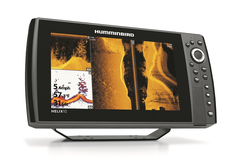
Fish With A Perfect 10 — Humminbird®’s New HELIX™ 10
The HELIX™ 10 features expansive and ultra-bright 1024H x 600V HD screen, AutoChart® Live for real-time mapping, and full networking capabilities
Boasting an impressive widescreen display, plus Humminbird®’s legendary fish-finding pedigree, Humminbird’s new HELIX™ 10 offers the ideal blend of beauty and brainpower. Identify interesting contours and structure using Humminbird imaging sonar, then map them in real-time with AutoChart® Live.
Like the rest of the expanding HELIX™ family, HELIX™ 10 offers industry-best screen brightness, advanced imaging technologies, an Ethernet port for networking multiple units and technologies like Minn Kota® i-Pilot® Link™ and Humminbird 360 Imaging®, and one-of-a-kind AutoChart® Live, which allows anglers to make their own maps in real-time, no PC, server or Cloud required.
The HELIX™ 10 Series comprises three models, all with an incredibly user-friendly operating system called REFLEX Interface, X-Press™ Menu System keypad control, 3 “shortcut” preset buttons, 1024H x 600V HD 10.1-inch 65,000-colors TFT display, and allow for gimbal mounting, or in-dash mounting with optional kit. International models support 200/50kHz. Optional 50 kHz transducers are available for extreme deep-water use. To obtain 1000 watts, optional deep-water transducer required.
HELIX™ 10 Sonar – GPS, HELIX™ 10 DI – GPS, and HELIX™ 10 SI – GPS all feature dual SD card slots for use with advanced cartography or to save screenshots, sonar recordings or waypoints.
All models in the HELIX 10 family feature upgradable software.
HELIX™ 10 SONAR - GPS
• Offers DualBeam PLUS™ w/SwitchFire® Sonar and GPS chartplotting with internal 10Hz Precision GPS receiver for 2,500 waypoints, 45 routes, 50 tracks and 20,000 waypoints
• Includes built-in Humminbird ContourXD™ base maps and is compatible with Humminbird LakeMaster® charts
• AutoChart® Live included for real-time mapping
• Navionics® Gold/HotMaps™ and Platinum+ compatible
• 8000 W (PTP); 1000 W (RMS)
• Included XNT 9 20 T transducer with 200/83kHz frequencies for 20- and 60-degree coverage, respectively
• Water surface temperature gauge built into transducer
• GPS speed included
• 1500 feet depth capability; 3000 feet with 50kHz transducer
• Ethernet port for networking capabilities
• Add-ons include Minn Kota® i-Pilot® Link™, 360 Imaging™, Bluetooth® remote, Autopilot™, HD Radar, AIS, NMEA 2000®, GPS Heading Sensor and 5-Port Ethernet Switch
HELIX™ 10 DI – GPS
• Functionality includes DualBeam PLUS™ Sonar w/ SwitchFire®, GPS chartplotting with internal GPS receiver and Down Imaging®
• Includes built-in Humminbird ContourXD base maps and is compatible with Humminbird LakeMaster® charts
• AutoChart Live included for real-time mapping
• Navionics® Gold/HotMaps™ and Platinum+ compatible
• 8000 W (PTP); 1000 W (RMS) with optional deep-water transducer
• Included XNT 9 DI T transducer features 455/800 kHz frequencies for 45- and 75-degree DI coverage; DualBeam PLUS™ w/SwitchFire® via the same transducer at 200/455 kHz frequencies for 28- and 16-degree coverage, respectively
• Water surface temperature gauge built into transducer
• GPS speed included
• Ethernet port for networking capabilities
• 600 feet depth-capable sonar; Down Imaging, 350 feet
• Add-ons include Minn Kota® i-Pilot®, Link™, 360 Imaging™, Bluetooth® remote, Autopilot, HD Radar, AIS, NMEA 2000®, GPS Heading Sensor and 5-Port Ethernet Switch
HELIX™ 10 SI – GPS
• The flagship unit of the HELIX™ 10 family features DualBeam PLUS™ Sonar w/ SwitchFire®, GPS chartplotting with internal GPS receiver, HD Down Imaging®, and HD Side Imaging®
• Includes Humminbird ContourXD base maps and is compatible with Humminbird LakeMaster® charts
• AutoChart® Live included for real-time mapping
• Navionics® Gold/HotMaps™ and Platinum+ compatible
• 8000 W (PTP); 1000 W (RMS) with optional deep-water transducer
• Included XHS 9 HDSI 180 T transducer for HD Side Imaging®/HD Down Imaging® with 180-degrees coverage: 455kHz/(2) 86-degrees; 800kHz/(2) 55-degrees DualBeam Plus w/SwitchFire®: 200kHz/20-degrees; 83 kHz/60-degrees
• Water surface temperature gauge built into transducer
• GPS speed included
• 1500 feet depth-capable sonar (3000 feet with optional 50 kHz transducer); Down Imaging®, 150 feet; Side Imaging, 150 feet, left and right
• Ethernet port for networking capabilities
• Add-ons include Minn Kota® i-Pilot® Link™, 360 Imaging™, Bluetooth® remote, Autopilot, HD Radar, AIS, NMEA 2000®, GPS Heading Sensor and 5-Port Ethernet Switch
EDITOR’S NOTE
Johnson Outdoors Marine Electronics, Inc. consists of the Humminbird®, LakeMaster®, Minn Kota® and Cannon® brands. Humminbird® is a leading innovator and manufacturer of fishfinders, fishfinder/GPS combo units, ice flashers and digital depth gauges. LakeMaster® is the premier brand of high-definition electronic fishing charts. Minn Kota® is the world’s leading manufacturer of electric trolling motors, as well as offers a complete line of shallow water anchors, battery chargers and marine accessories. Cannon® is the leader in controlled-depth fishing and includes a full line of downrigger products and accessories.
For sales information:
Motocraft SA
Alimou Ave. 48
17455 Alimos
phone 210 9888288
email: motocraft@motocraft.gr
For more information, visit:
www.humminbird.com
www.facebook.com/Humminbird
www.youtube.com/Humminbird